Malakpet receives the highest rainfall of 56.5 mm on Monday
Tue 25 Jul 2023, 10:51:31
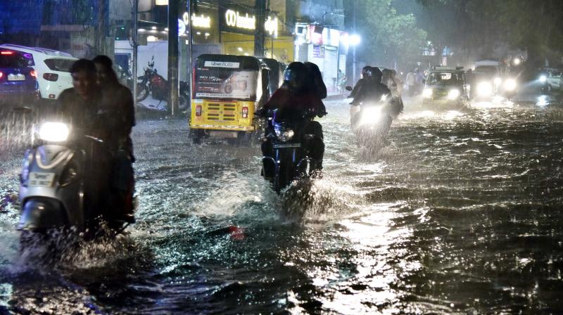
In an hour, starting of rain at 5 pm, the city was gridlocked as officegoers were caught unawares on their way back home. Waterlogged roads held commuters hostage, as, in some instances, motorists could not even spot the roads.
Fearful of falling into a pothole or manhole, motorists moved at a snail’s pace, battling decreased visibility and lightning bolts due to the sudden downpour.
While the rain lasted for a bit over an hour, it took its toll on the road network, with arterial roads and flyovers also being heavily inundated.
Starting from the northern part of the city, the thundershowers hit Tank Bund, Secretariat, Masab Tank, Humayunnagar, Mehdipatnam, Reti Bowli, Attapur, Gudimalkapur, Asifnagar, Rajendranagar, Langar Houz, Tolichowki, Golconda, Shaikpet, Manikonda, Filmnagar, Banjara Hills, Jubilee Hills, Gachibowli, Hitec City, Kondapur, Nampally, Moazzam Jahi Market, Ameerpet, LV Prasad Road, Begumpet, Punjagutta, Prashantnagar, GVK Mall Road, Khairatabad, Old City, Abids, Koti, Habsiguda, Tarnaka, Uppal, Moosarambagh bridge, Kukatpally, Miyapur, LB Nagar, Chandanagar, Malakpet, KBR Park, Sanjeevaiah Park, Chaderghat, Saroornagar and Santoshnagar.
Commuters said that the Metro Rail viaduct appeared like waterfalls, as rainwater gushed from the tracks onto the roads.
Traffic across the city was thrown out of order, with traffic halting at major junctions in the IT Corridor, including Ikea junction,
Hitex junction, Gachibowli and Raidurgam.
Hitex junction, Gachibowli and Raidurgam.
Cyberabad traffic police issued an alert, advising motorists to exercise caution while travelling and to check the weather forecast before leaving their offices.
There was also an instance of wall collapse, as lightning struck down a part of the Qutb Shahi Masjid Minar at Langar Houz.
Across the state, Ranga Reddy logged the highest rainfall, at 70.8 mm, followed by Suryapet, at 70 mm, and Hanamkonda, at 57 mm, according to the Telangana State Development and Planning Society report.
In city limits, Malakpet received the highest rainfall, 56.5 mm, followed by Saroornagar and Amberpet, at 51 mm each, and Charminar, at 49.3 mm.
According to the India Meteorological Department, the rain was caused due to the influence of a cyclonic circulation over the west-central and northwest Bay of Bengal, off the north Andhra Pradesh-south Odisha coast. Another low-pressure area has formed over the region, which is likely to intensify into a depression on July 26.
IMD said that the monsoon trough, at mean sea level, now passed through Deesa, Indore, Damoh, Pendra Road, Jagdalpur, and the centre of the low-pressure area over west-central and northwest Bay of Bengal.
The IMD said that the ‘shear zone’ persisted along with a cyclonic circulation over Kutch and the neighbouring region.
No Comments For This Post, Be first to write a Comment.
Most viewed from Hyderabad
Most viewed from World
AIMIM News
Asaduddin Owaisi questions PM Modi's China policy
Jan 08, 2025
Owaisi slams UP over police post near Sambhal mosque
Dec 31, 2024
Owaisi hails SC order on Places of Worship Act
Dec 13, 2024
AAP Corporator Tahir Hussain joins AIMIM party
Dec 11, 2024
Latest Urdu News
Most Viewed
May 26, 2020
Which political party will win the Delhi Assembly polls to be held on Feb 5?
Latest Videos View All
Like Us
Home
About Us
Advertise With Us
All Polls
Epaper Archives
Privacy Policy
Contact Us
Download Etemaad App
© 2025 Etemaad Daily News, All Rights Reserved.










.jpg)
