


Musi River Front Development: Consultants invited for master plan
Wed 15 May 2024, 00:05:09
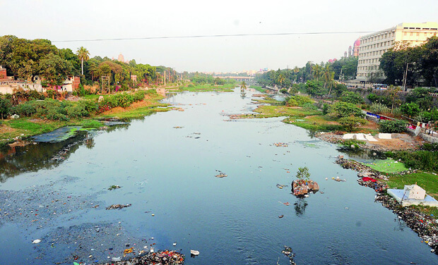
The State government is drawing grand plans for executing the River Musi Front Development project and consultants have been invited for preparing the aggregate master plan for the project. The master plan would be prepared for a site area covering 55 km of the River Musi. This excludes the one km influence zone on either side totaling to an area of 110 square km. Musi River Front Development Corporation invited the consultants last month and applications submitted by the applicants are likely to be opened on May 18.
The exercise to prepare the master plan is split into four components, including Blue-Green Master Plan, Land use Master Plan, Infrastructure Master Plan and Financial Master Plan. Among different exercises to be taken up, the consultants would have to conduct an analysis of existing climatic conditions and flora of the region for inputs into the master planning and preliminary design of the demarcated area. They would have to integrate specific measures for implementation of a sustainable development apart from those stipulated by government regulations. These measures would include integrated water management, rain water harvesting, water reuse, integrated solid waste management plan, use of renewable energy and use of sustainable materials during construction. The consultants would have to assess all the prior site surveys and validate the project boundary and
demarcation of the site. They have to carry out geotechnical investigations and sub-surface explorations for proposed bridges or highway structures over the river and high embankments and conduct all relevant laboratory and field tests on soil.
demarcation of the site. They have to carry out geotechnical investigations and sub-surface explorations for proposed bridges or highway structures over the river and high embankments and conduct all relevant laboratory and field tests on soil.
The consultants have to assess existing infrastructure and propose improvements to enable the flow of clean and recycled water into River Musi. They have to prepare a detailed master plan including geo-referenced cadastral maps for the identified land area.
Under Blue-Green Master Plan focus was being laid on technology solutions for flow of clean or recycled water in the river. Bioengineering techniques for stabilizing the river banks and promoting natural flood plain processes to mitigate impact of flooding. Similarly, under Green Master plan plans are on to develop open space and landscape strategies, besides beautification. In the Land Use master plan, a base map would be prepared, which highlights the built up features within the site, existing road network, water bodies, streams, hillocks and forests etc.
Under Infrastructure master plan, a design basis report for all roads, bridges and utility services would be prepared. In the Financial Master Plan, a financial feasibility model would be developed by considering different parameters, including costs for development, project structuring etc.
No Comments For This Post, Be first to write a Comment.
Most viewed from Hyderabad
.jpg)
.jpg)
.jpg)
.jpg)
.jpg)
.jpg)
.jpg)
.jpg)
.jpg)
Most viewed from World
.jpg)

.jpg)
.jpg)
.jpg)


Todays Epaper

English Weekly


AIMIM News


Delhi Assembly polls: Owaisi leads Padyatra in Okhla
Feb 01, 2025

We reject this Waqf Amendment Bill: Asaduddin Owaisi
Jan 30, 2025


Latest Urdu News
Most Viewed
May 26, 2020
Which team will win the ICC Men's Champions Trophy 2025 held in Pakistan/Dubai?
Latest Videos View All


Like Us
Home
About Us
Advertise With Us
All Polls
Epaper Archives
Privacy Policy
Contact Us
Download Etemaad App
© 2025 Etemaad Daily News, All Rights Reserved.