


Another Low-pressure Area in Bay by Thursday
Tue 03 Sep 2024, 11:52:07
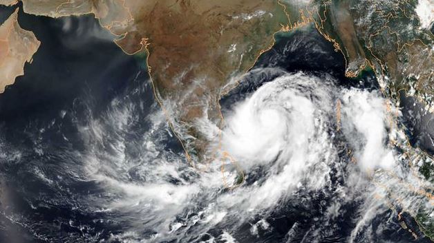
Visakhapatnam: As people are still struggling to come out of the floods in Vijayawada, Guntur, the IMD Amaravati has announced the formation of a fresh low-pressure area in West Central and adjoining Northwest Bay of Bengal by September 5. “It will take another two days to assess its intensity and trajectory,’’ said Venkat Rao of IMD Amaravati.
Meanwhile, the monsoon trough at mean sea level now passes through Jaisalmer, Raisen, Chhindwara, centre of depression over East Vidarbha and adjoining Telangana, Machilipatnam, and thence
southeastwards to East Central Bay of Bengal.
southeastwards to East Central Bay of Bengal.
The IMD report said strong surface winds with speeds reaching 30-40 kmph are likely at isolated places over north and south coastal Andhra Pradesh, Yanam, and Rayalaseema on Tuesday, and thereafter, thundershowers would commence from Wednesday till September 5.
During the last 24 hours ending at 8.30 am on Monday, Araku Valley in ASR district received a rainfall of 2.5cms, Kurupam (Parvathipuram Manyam) 2 cms and Kukunoor (Eluru) 2cms.
No Comments For This Post, Be first to write a Comment.
Most viewed from National
.jpg)
.jpg)
.jpg)
.jpg)


Most viewed from World
.jpg)
.jpg)
.jpg)
.jpg)
.jpg)
.jpg)
.jpg)
.jpg)
.jpg)
.jpg)
.jpg)
.jpg)

Todays Epaper

English Weekly


AIMIM News

Owaisi hails SC order on Places of Worship Act
Dec 13, 2024

AAP Corporator Tahir Hussain joins AIMIM party
Dec 11, 2024


BJP-SP two sides of same coin: Asaduddin Owaisi
Nov 19, 2024

Latest Urdu News
Most Viewed
May 26, 2020
Do you think AAP will perform better in Delhi polls without alliance?
Latest Videos View All


Like Us
Home
About Us
Advertise With Us
All Polls
Epaper Archives
Privacy Policy
Contact Us
Download Etemaad App
© 2024 Etemaad Daily News, All Rights Reserved.