


Cyclonic Mandous continues to intensity in severe category
Fri 09 Dec 2022, 10:31:07
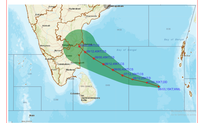
Chennai: The Severe Cyclonic storm “Mandous” over Southwest Bay of Bengal moved nearly west-northwestwards and lay centered over South West Bay of Bengal about 350 km south southeast of Chennai and about 270 km east South east of Karaikal. It is very likely to maintain its intensity in the severe category and gradually weaken into a cyclonic storm today.
It is expected to continue to move west northwestwards and cross between Puducherry and Sriharikota around Mahabalipuram with sustained windspeed gusting up to 85 km at midnight and early hours of tomorrow. State Chief Secretary V. IraiAnbu took stock of the situation with top officials of the Government this evening. In the event of suspension of services, flights might be diverted to Bangalore and Hyderabad airports.
Cyclone Mandous moving towards the coastal areas the Met department has predicted heavy rains with strong winds in many districts. Educational institutions in many districts have been closed and exams have been
postponed. Port Danger Signal 6 has been hoisted in Chennai and Ennore ports and signal 5 in other ports. Ships in the harbours have been moved to safer seas.
postponed. Port Danger Signal 6 has been hoisted in Chennai and Ennore ports and signal 5 in other ports. Ships in the harbours have been moved to safer seas.
The Indian Coast Guard helicopter rescued three persons stranded in a rig near Karaikal yesterday. All the teams have been kept on standby for emergency situations in case of inclement weather at the airport. Non-scheduled operators will be asked to relocate their aircraft in case of heavy crosswinds. NDRF teams have been deployed and district administrations have been issued necessary instructions to act upon the situation. Temporary shelters have been kept ready to shift those living near the seas.
The State Emergency control centre is closely monitoring the situation. The Government has said that all relevant and immediate information relating to the cyclone can be accessed in TN SMART APP and an advisory has been issued to store the essentials for emergencies.
No Comments For This Post, Be first to write a Comment.
Most viewed from National


.jpg)
.jpg)
.jpg)
.jpg)


Most viewed from World


.jpg)
.jpg)
.jpg)
.jpg)


Todays Epaper

English Weekly


AIMIM News


Delhi Assembly polls: Owaisi leads Padyatra in Okhla
Feb 01, 2025

We reject this Waqf Amendment Bill: Asaduddin Owaisi
Jan 30, 2025


Latest Urdu News
Most Viewed
May 26, 2020
Which team will win the ICC Men's Champions Trophy 2025 held in Pakistan/Dubai?
Latest Videos View All


Like Us
Home
About Us
Advertise With Us
All Polls
Epaper Archives
Privacy Policy
Contact Us
Download Etemaad App
© 2025 Etemaad Daily News, All Rights Reserved.