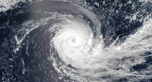
Depression over East Central Bay of Bengal intensifies into deep depression
Mon 24 May 2021, 09:54:51

The depression over the East Central Bay of Bengal has intensified into a deep depression. It is likely to deepen into a cyclonic storm today and further into a very severe cyclonic storm by tomorrow. Indian Meteorological Department has said that it may cross North Odisha-West Bengal coast on Wednesday.
According to the IMD, it now lies centred at about 540 kilometres south- south east of Paradeep in Odisha.Backgrounded against the preliminary cyclonic forecast of a wind speed between 120 to 165 kilometres per hour, heavy to very heavy rainfall between 250 to 300 millimetres and accompanying storm surges between 3 to 4 metres, the Odisha Government is ready with all the
preemptive and preparatory plans to face the probable cyclone, should the landfall happen anywhere near the North Odisha coast.
preemptive and preparatory plans to face the probable cyclone, should the landfall happen anywhere near the North Odisha coast.
While primacy would be given to prompt evacuation of vulnerable people in vulnerable places , including those living in low lying areas, the government has also made adequate arrangements for cyclone shelters with necessary logistics, focus is also being made to ensure the smooth functioning of covid-19 facilities in the areas likely to be affected by the impending cyclone. Meanwhile, 22 NDRF, 66 ODRAF and 177 fire fighting teams are already in position for rescue relief and restoration operations.
No Comments For This Post, Be first to write a Comment.
Most viewed from National
Most viewed from World
AIMIM News
Asaduddin Owaisi questions PM Modi's China policy
Jan 08, 2025
Owaisi slams UP over police post near Sambhal mosque
Dec 31, 2024
Owaisi hails SC order on Places of Worship Act
Dec 13, 2024
AAP Corporator Tahir Hussain joins AIMIM party
Dec 11, 2024
Latest Urdu News
Most Viewed
May 26, 2020
Which political party will win the Delhi Assembly polls to be held on Feb 5?
Latest Videos View All
Like Us
Home
About Us
Advertise With Us
All Polls
Epaper Archives
Privacy Policy
Contact Us
Download Etemaad App
© 2025 Etemaad Daily News, All Rights Reserved.


