


Heavy rain likey across Telangana today
Mon 27 Jun 2016, 12:07:35
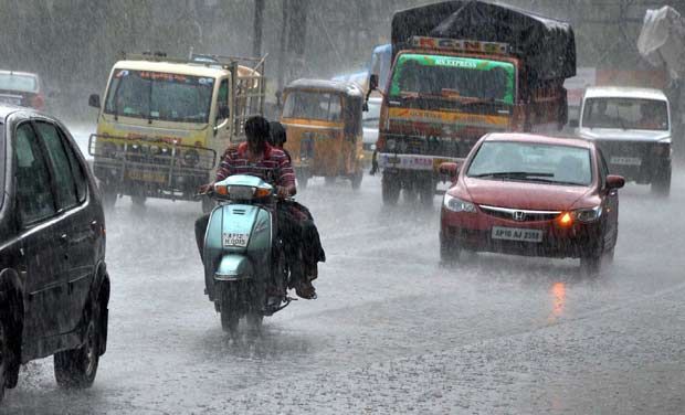
The Met office warned on Sunday that heavy rain was likely to occur at isolated places in all districts of Telangana on June 27 and 28, as the Southwest Monsoon has been active over the State.
Under the influence of upper air cyclonic circulation over the west-central Bay of Bengal off the coastal districts, a low pressure was formed over the same area at 5.30 am on Sunday. It lies over the west-central and adjoining north-west Bay off south Odisha and north Andhra Pradesh.
The associated upper- air cyclonic circulation is likely to become a well marked low- pressure area during the next 24 hours. The trough now runs to south Tamil Nadu across coastal AP. Light to moderate rain/thundershowers are likely at many places in Telangana from June 27 to
30.
30.
There will be no major change in the weather outlook during the subsequent three days, according to the forecast. During the last 24 hours, rain occurred at many places in the State, with Aswapuram, Sathupalle, Burgampadu and Bhadrachalam ( all in Khammam district) receiving 17, 13 11 and nine cm of rain respectively.
The chief amounts of rainfall (in cm) in other parts of State were: Suryapet, Tekulapalle eight cm each, Gundala, Madhira, Manthani, Venkatapuram, Govindaraopet, Perur and Ramagundam seven cm each, Sircilla, Pinapaka, Achareddy, Manuguru, Mulakalapalle six cm each.
Gambhiraopet, Kothagudem, Palwancha, Chandrugonda, Eturunagaram five cm each, Palakurthi, Luxettipet, Sangareddy, Yellandu, Pitlam, Hyderabad four cm each.
No Comments For This Post, Be first to write a Comment.
Most viewed from National


Most viewed from World


.jpg)
.jpg)
.jpg)
.jpg)
.jpg)

Todays Epaper

English Weekly


AIMIM News


Latest Urdu News
Most Viewed
May 26, 2020
Do you think Canada-India relations will improve under New PM Mark Carney?
Latest Videos View All


Like Us
Home
About Us
Advertise With Us
All Polls
Epaper Archives
Privacy Policy
Contact Us
Download Etemaad App
© 2025 Etemaad Daily News, All Rights Reserved.