NASA satellites break Guiness World Record
Sat 05 Nov 2016, 13:15:19

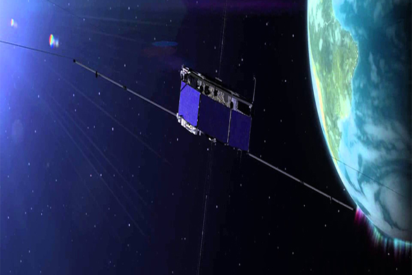
NASA's Magnetospheric Multiscale mission (MMS) has set the Guinness World Record for highest altitude fix of a GPS signal - at 70,000 kilometres above the surface of the Earth.
Operating in a highly elliptical orbit around Earth, the four MMS spacecraft incorporate Global Positioning System (GPS) measurements into their precise tracking systems, which require extremely sensitive position and orbit calculations to guide tight flying formations.
Earlier this year, MMS achieved the closest flying separation of a multi-spacecraft formation with only 7.2 km between the four satellites. When the satellites are closest to Earth, they move at up to 35,405 km per hour, making them the fastest known operational use of a GPS receiver.
When MMS is not breaking records, it conducts ground-breaking science. Still in the first year of its prime mission, MMS is giving scientists new
insight into Earth's magnetosphere.The mission uses four individual satellites that fly in a pyramid formation to map magnetic reconnection – a process that occurs as the sun and Earth's magnetic fields interact.
insight into Earth's magnetosphere.The mission uses four individual satellites that fly in a pyramid formation to map magnetic reconnection – a process that occurs as the sun and Earth's magnetic fields interact.
Precise GPS tracking allows the satellites to maintain a tight formation and obtain high resolution three-dimensional observations.Understanding the causes of magnetic reconnection is important for understanding phenomena around the universe from auroras on Earth, to flares on the surface of the sun, and even to areas surrounding black holes.
Next year, MMS will enter Phase 2 of the mission and the satellites will be sent in to an even larger orbit where they will explore a different part of Earth's magnetosphere.
During that time, the satellites are anticipated to break their current high altitude GPS record by a factor of two or more.
No Comments For This Post, Be first to write a Comment.
Most viewed from Specials
Most viewed from World
AIMIM News
Latest Urdu News
Most Viewed
May 26, 2020
Do you think Canada-India relations will improve under New PM Mark Carney?
Latest Videos View All
Like Us
Home
About Us
Advertise With Us
All Polls
Epaper Archives
Privacy Policy
Contact Us
Download Etemaad App
© 2025 Etemaad Daily News, All Rights Reserved.


.jpg)
.jpg)
.jpg)


